Lahabali kɔligu:The National Archives UK - CO 1069-34-50 1 001.jpg

Faal maa maŋmaŋa (839 × 706 pixels, file size: 154 KB, MIME type: image/jpeg)

Lahabali kɔligu ŋɔ yila Wikimedia Commons ka tuun' shɛŋa ni tooi mali di bukaata. Buɣisiri shɛli din be lahabali kɔligu buɣisibu yaɣili din n do gbunni ŋɔ

Lahabali jia

Buɣisibu

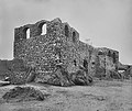
This image is a copy of detail from File:The National Archives UK - CO 1069-34-50.jpg Description: Ruins of Fort Austenborg (Danish) at Jassy. (= The Ruins of Fort Augustaborg at Teshie in the contemporary Ghana.)

Location: Jassy (= Teshie)

Date:

Our Catalogue Reference: Part of CO 1069/34

This image is part of the Colonial Office photographic collection held at The National Archives, uploaded as part of the Africa Through a Lens project. Feel free to share it within the spirit of the Commons.

Our records about many of these images are limited. If you have more information about the people, places or events shown in an image, please use the comments section below. We have attempted to provide place information for the images automatically but our software may not have found the correct location.

Alternatively you could use the <a href='https://suggestify.appspot.com/'>Suggestify</a> tool to suggest the location of a picture.

For high quality reproductions of any item from our collection please contact our <a href='http://www.nationalarchives.gov.uk/imagelibrary' rel='nofollow'>image library</a>
Dabisili kalinli 1890s
date QS:P,+1890-00-00T00:00:00Z/8
(?)
Nyabli

Africa Through a Lens

This file is from the collections of The National Archives (United Kingdom), catalogued under document record CO1069. For high quality reproductions of any item from The National Archives collection please contact the image library.

This tag does not indicate the copyright status of the attached work. A normal copyright tag is still required. See Commons:Licensing.


العربيَّة | English | français | italiano | македонски | +/−

Sab'sabira The National Archives UK - Flickr account
Object location5° 35′ 00″ N, 0° 06′ 00″ W Kartographer map based on OpenStreetMap.View this and other nearby images on: OpenStreetMapinfo

Fukumisi shahira niŋbu

Royal Coat of Arms of the United Kingdom
This file is licensed under the Open Government Licence version 1.0 (OGL v1.0).
You are free to:
  • copy, publish, distribute and transmit the Information;
  • adapt the Information;
  • exploit the Information commercially for example, by combining it with other Information, or by including it in your own product or application.
You must, where you do any of the above:
  • acknowledge the source of the Information by including any attribution statement specified by the Information Provider(s) and, where possible, provide a link to this licence;
  • ensure that you do not use the Information in a way that suggests any official status or that the Information Provider endorses you or your use of the Information;
  • ensure that you do not mislead others or misrepresent the Information or its source;
  • ensure that your use of the Information does not breach the Data Protection Act 1998 or the Privacy and Electronic Communications (EC Directive) Regulations 2003.

See the Open Government Licence page on Meta-Wiki for more information.


Attribution information, such as the author's name, e-mail, website, or signature, that was once visible in the image itself has been moved into the image metadata and/or image description page. This makes the image easier to reuse and more language-neutral, and makes the text easier to process and search for. Commons discourages placing visible author information in images.

Indonesia | العربيَّة | Boarisch | беларуская (тарашкевіца)‎ | বাংলা | català | čeština | Deutsch | Ελληνικά | English | español | eesti | فارسی | suomi | français | עברית | magyar | italiano | 한국어 | македонски | മലയാളം | Plattdüütsch | Nederlands | polski | português | português do Brasil | русский | sicilianu | slovenščina | தமிழ் | Türkçe | 中文 | +/−

Captions

Add a one-line explanation of what this file represents

Items portrayed in this file

ŋmahanli

5°34'59.999"N, 0°6'0.000"W

157,358 byte

706 pixel

839 pixel

image/jpeg

checksum English

9d84c7dab23dc447ea1e37b5b5fb1762f3677323

Faal tarihi

Dihimi dabisili/saha n-nya kɔl' bihi kamani di ni di yina shɛm

Zuŋɔ dabisili/SahaThumbnailDi tarisiŋun sutɔhibu
din na chana16:53, 25 Silimin gɔli August 2015Thumbnail for version as of 16:53, 25 Silimin gɔli August 2015839 × 706 (154 KB)Edithsmewatermark removed
17:23, 12 Silimin gɔli April 2012Thumbnail for version as of 17:23, 12 Silimin gɔli April 2012859 × 774 (165 KB)Katharinaivfirst trial of an improvement
17:19, 12 Silimin gɔli April 2012Thumbnail for version as of 17:19, 12 Silimin gɔli April 2012859 × 774 (107 KB)Katharinaiv{{Information |Description= This image is a copy of detail from File:The National Archives UK - CO 1069-34-50.jpg <b>Description:</b> Ruins of Fort Austenborg (Danish) at Jassy. ''(= The Ruins of Fort Augustaborg at Teshie in the contemporary Ghan...

Din doli ŋɔ na yaɣili tuma nima zaŋ ti lahabali kɔligu ŋɔ:

Duniya zaa lahabali kɔligu zaŋ tum tuma

Wikis shɛŋa ŋan dolina ŋɔ gba malila faal ŋɔ n kuri bukaata: