Lahabali kɔligu:Map of Assyria.png
Jɔhiyuli maa galisim:800 × 550 anfooni bihi bihi. Din pahi resolutions: 320 × 220 anfooni bihi bihi | 640 × 440 anfooni bihi bihi | 1,024 × 704 anfooni bihi bihi | 1,280 × 880 anfooni bihi bihi | 1,983 × 1,363 anfooni bihi bihi.
Faal maa maŋmaŋa (1,983 × 1,363 pixels, file size: 160 KB, MIME type: image/png)
| Buɣisibu |
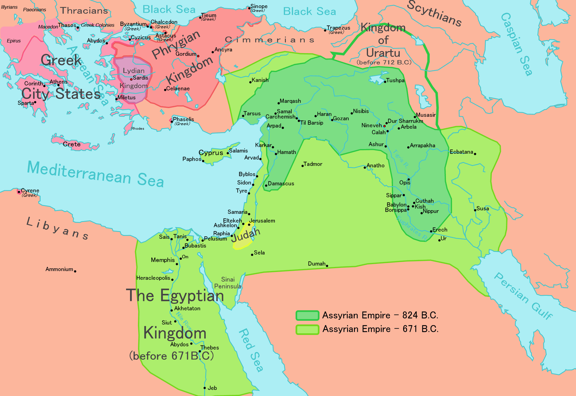
[] English: Map of the Assyrian Empire Español: Extensión del Imperio Asirio Polski: Mapa Asyrii w 824 i 671 r. p.n.e. Português: Extensão do Império Assírio العربية : خارطة الإمبراطوريَّة الآشوريَّة. فارسی : نقشه امپراتوری آشور |
|||
| Dabisili kalinli | ||||
| Nyabli |
Own work data from
|
|||
| Sab'sabira | Ningyou | |||
| Soli tibu (Lahabali kɔligu ŋɔ labitum zaŋ tum tuma) |
|
|||
| Other versions |
[]
|


Faal tarihi
Dihimi dabisili/saha n-nya kɔl' bihi kamani di ni di yina shɛm
| Zuŋɔ dabisili/Saha | Thumbnail | Di tarisi | ŋun su | tɔhibu | |
|---|---|---|---|---|---|
| din na chana | 12:32, 24 Silimin gɔli May 2018 | | 1,983 × 1,363 (160 KB) | Capmo | corrected typos in Trapezus and Hamath |
| 18:33, 12 Silimin gɔli September 2010 |  | 1,983 × 1,363 (148 KB) | Ras67 | cropped and squeezed | |
| 00:35, 1 Silimin gɔli September 2010 |  | 1,985 × 1,365 (161 KB) | Capmo | typo in word "Aegean"; 256 colors | |
| 21:05, 21 Silimin gɔli January 2010 |  | 1,985 × 1,365 (645 KB) | Megistias | Border around map, Details | |
| 14:51, 26 Silimin gɔli February 2006 |  | 1,985 × 1,365 (640 KB) | Ningyou | This is a large map of Assyria, made by Ningyou. For translations of this map, contact Ningyou. Category:Assyria |
Lahibali kɔligu zaŋ tum tuma
Din doli ŋɔ na yaɣili tuma nima zaŋ ti lahabali kɔligu ŋɔ:
Duniya zaa lahabali kɔligu zaŋ tum tuma
Wikis shɛŋa ŋan dolina ŋɔ gba malila faal ŋɔ n kuri bukaata:
- Zaŋ tum tuma af.wikipedia.org zuɣuc
- Zaŋ tum tuma als.wikipedia.org zuɣuc
- Zaŋ tum tuma am.wikipedia.org zuɣuc
- Zaŋ tum tuma an.wikipedia.org zuɣuc
- Zaŋ tum tuma arc.wikipedia.org zuɣuc
- Zaŋ tum tuma ar.wikipedia.org zuɣuc
- Zaŋ tum tuma ast.wikipedia.org zuɣuc
- Zaŋ tum tuma azb.wikipedia.org zuɣuc
- Zaŋ tum tuma az.wikipedia.org zuɣuc
- Zaŋ tum tuma ba.wikipedia.org zuɣuc
- Zaŋ tum tuma be.wikipedia.org zuɣuc
- Zaŋ tum tuma bg.wikipedia.org zuɣuc
- Zaŋ tum tuma bn.wikipedia.org zuɣuc
- Zaŋ tum tuma ca.wikipedia.org zuɣuc
- Zaŋ tum tuma ckb.wikipedia.org zuɣuc
- Zaŋ tum tuma cs.wikipedia.org zuɣuc
- Zaŋ tum tuma cv.wikipedia.org zuɣuc
- Zaŋ tum tuma cy.wikipedia.org zuɣuc
- Zaŋ tum tuma da.wikipedia.org zuɣuc
- Zaŋ tum tuma de.wikipedia.org zuɣuc
- Zaŋ tum tuma el.wikipedia.org zuɣuc
Yulima more global usage zaŋ chaŋ lahabali kɔligu ŋɔ.