Lahabali kɔligu:Greater Accra districts.png

Jɔhiyuli maa galisim:800 × 560 anfooni bihi bihi. Din pahi resolutions: 320 × 224 anfooni bihi bihi | 640 × 448 anfooni bihi bihi | 995 × 696 anfooni bihi bihi.
Faal maa maŋmaŋa (995 × 696 pixels, file size: 14 KB, MIME type: image/png)
Lahabali jia
| Buɣisibu |
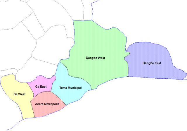
English: Map of the districts of the Greater Accra region of Ghana. Created by Rarelibra for public domain use. Created using MapInfo Professional v7.5 and various mapping resources. |
||
| Dabisili kalinli | 28 Silimin gɔli June 2006 (original upload date) | ||
| Nyabli | Amaŋmaŋ tuma | ||
| Sab'sabira | User:Rarelibra | ||
| Other versions |
|

Fukumisi shahira niŋbu
| I, the copyright holder of this work, release this work into the public domain. This applies worldwide. In some countries this may not be legally possible; if so: I grant anyone the right to use this work for any purpose, without any conditions, unless such conditions are required by law. |
Original upload log
- (del) (cur) 07:36, 5 March 2006 . . Rarelibra (Talk | contribs) . . 1056x816 (29,321 bytes) (Map of the districts of the Greater Accra region of Ghana. Created by Rarelibra for public domain use. Created using MapInfo Professional v7.5 and various mapping resources.)
Faal tarihi
Dihimi dabisili/saha n-nya kɔl' bihi kamani di ni di yina shɛm
| Zuŋɔ dabisili/Saha | Thumbnail | Di tarisi | ŋun su | tɔhibu | |
|---|---|---|---|---|---|
| din na chana | 14:00, 6 Silimin gɔli January 2021 | | 995 × 696 (14 KB) | Jakob Gottfried | cropped |
| 10:52, 28 Silimin gɔli June 2006 |  | 1,056 × 816 (29 KB) | Ahanta | from:en:Districts of ghana Map of the districts of the Greater Accra region of Ghana. Created by Rarelibra for public domain use. Created using MapInfo Professional v7.5 and various mapping resources. [edit] I, the creator of this work, hereby release it |
Lahibali kɔligu zaŋ tum tuma
Din doli ŋɔ na yaɣili tuma nima zaŋ ti lahabali kɔligu ŋɔ:
Duniya zaa lahabali kɔligu zaŋ tum tuma
Wikis shɛŋa ŋan dolina ŋɔ gba malila faal ŋɔ n kuri bukaata:
- Zaŋ tum tuma cs.wikipedia.org zuɣuc
- Zaŋ tum tuma de.wikipedia.org zuɣuc
- Zaŋ tum tuma en.wikipedia.org zuɣuc
- Zaŋ tum tuma es.wikipedia.org zuɣuc
- Zaŋ tum tuma fr.wikipedia.org zuɣuc
- Zaŋ tum tuma it.wikipedia.org zuɣuc
- Zaŋ tum tuma ko.wikipedia.org zuɣuc
- Zaŋ tum tuma nl.wikipedia.org zuɣuc
- Zaŋ tum tuma pl.wikipedia.org zuɣuc
- Zaŋ tum tuma pt.wikipedia.org zuɣuc
- Zaŋ tum tuma ro.wikipedia.org zuɣuc
- Zaŋ tum tuma tr.wikipedia.org zuɣuc
- Zaŋ tum tuma tw.wikipedia.org zuɣuc
- Zaŋ tum tuma uk.wikipedia.org zuɣuc